


Baiyin City
 Baiyin City is at the center of Gansu Province, and is also called Copper City. It occupies a converging zone of the Loess Plateau and the Tengger Desert. As a prefectural-level city, it governs Baiyin District, Pingchuan District, Jingyuan County, Jingtai County, and Huining County. It covers an area of 21209 square kilometers and has a population of 1708751 people. Early in the reign of the Hongwu Emperor of the Ming Dynasty, it began to mine gold and silver in large-scale, with a daily output of several kilograms of gold. The Qing government decided to set up a mining administration named “Silver Factory (Baiyin Chang)", ten kilometers away from the Phoenix Mountain and Flaming Mountain. This is the origin of city’s name.
History of Baiyin
Baiyin means silver. As the name suggested, the city is a treasure land, whose mining industry began as early as the Han Dynasty (206BC-220AD). During the end of Tang Dynasty (618-907) to the start of the Song Dynasty (960-1127), it was once occupied by the Tubo Kingdom of Tibet. By the Ming Dynasty (1368-1644), mine industry of this area reached its zenith, and hence its name. Early in the reign of the Hongwu Emperor of the Ming Dynasty, it began to mine gold and silver in large-scale, with a daily output of several kilograms of gold. The Qing Dynasty(1644-1911) government decided to set up a mining administration named “Silver Factory", ten kilometers away from the Phoenix Mountain and Flaming Mountain. This is the origin of city’s name.
Geography of Baiyin
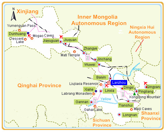
Located in the transition area from the Tengger Desert and the offshoots of Qilian Mountains to the Loess Plateau, the terrain basically slopes downward from southeast to northwest. The Yellow River zigzags through the city taking on a shape of 'S'.
In a narrow shape, Baiyin looks like a peach leaf in map and its southeast is higher than northwest. Traversed by the Yellow River in the middle of the territory, Baiyin has been divided into two parts, the northwest and the southeast. From northwest to southeast, Jingtai, Jingyuan and Huining these three counties constitutes the stem of peach leaf. From west to east, Baiyin District, Jingyuan County and Pingchuan District line up in the center of the leaf. The total length of Yellow River flowing through city is 258km long, forming a basin area of 14710 square kilometers. The total area of Baiyin is 21.2 thousand square kilometers, covering 4.4% of the total area of Gansu Province. Baiyin is a city rich in mineral resources, such as copper, coal, clay, limestone and gypsum, etc.Tourism in Baiyin
Baiyin’s resources for tourism development are rich and unique. Yellow River Stone Forest is a national geological park honored as “Chinese natural wonder" The sacred Huining County where the three main Red Armies historically realigned in the Long March, is the base for national patriotism education. There are some prominent scenic spots in Baiyin. The layout of its major tourism sites is “one belt with two wings and one line". One belt is the Scenic Zone along the Yellow River. Along the belt, you can find Jingtai Stone Forest, The Great Gorge, Jingyuan Yellow River Park, Silong Holiday Resort Village, Five Buddhas Temple, North Wudang Mountain, Water wheels and Sheepskin rafts. The two wings are the two sides of the Yellow River. On the northwest is Jingtai County, while on the southeast is Huining County. The natural landscape and red tourism are typical on the two wings -- Shoulu Mountain Changling Mountain, Tiemu Mountain, Quwu Mountain and Hasi Mountain as well as Huining Realignment Tower. One line is the Silk Road crossing from south to north Baiyin, along which are Ancient City Lachila, Guocheng Pass, Faquan Temple, Sierwan Grottoes, Five Buddhas Temple, Tiger City, Luyang City and Hongshuibu Fortress. Ancient cities, passes, grottoes and temples make up the cultural landscape along this line.
 Ask Questions ?