
Skype: neodalle-travel
Tel: +86 135 7447 2266
E-mail: sales@visitaroundchina.com
 Located in the central region of the Inner Mongolia Autonomous Region, Ulanqab / Wulanchabu City borders Hebei Province in the east and Shanxi Province in the south. Within Inner Mongolia, it neighbors Xilingol League (Meng) in the northeast and the capital city of the autonomous region, Hohhot in the west. In the north, it shares a boundary with Outer Mongolia.
History of Ulanqab
During the Warring States Period (476BC-221BC), Ulanqab was jointly governed by Zhao State and the Hun. The Qin Dynasty (221BC-206BC) brought it into its territory. Later, during the times of war after the national subjugation of the Qin, the Huns occupied most of this area. They founded their supreme organ of authority in present Siziwang Qi. During the hundreds of years since the Song Dynasty (960-1279), several ethnic minorities of Northern China have gone to live there. It was formally named Wulanchabu in the early Qing Dynasty (1644-1911).
What to see in Ulanqab?
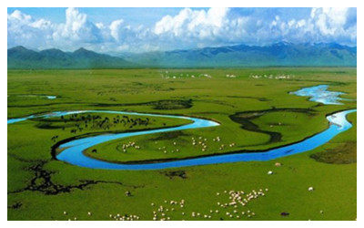
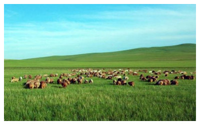
Ulanqap, which means "HongShanKou" in Mongolian, is about 55 thousand square kilometers. Since the ancient times here is full of beautiful mountains, rivers and lush vegetation. The place contains various types of natural landscape, strong feature of nationalities, long history and rich culture such as grasslands, forests, mountains and rivers, lakes. Here lists top attractions in Ulanqab.
 |
 |
 |
| Gegentala Grassland | Huitengxile Grassland | Daihai Lake |
When to visit Ulanqab?
Situated in the middle temperate climatic zone, Ulanqab City has a continental monsoon climate. With the Daqing Mountain as a divisor, the south region is warmer and wetter, while the north is windy. Precipitation is mainly concentrated during the period from July to September. The annual average temperature ranges from 0 C to 18 ºC. It is chilly in winter and cool in summer in Ulanqab. Summer and autumn are the most favorable seasons to pay a visit.
How to reach Ulanqab?
By air: Ulanqab is both easy to get to and to leave due to its accessibility to several surrounding airports which are all connected by expressways. The seat of the city's government, Jining District, is about 150 kilometers (93 miles) or about 1.5 hours from Hohhot Baita Airport, 300 kilometers (186 miles) or three hours from Baotou Airport, and 360 kilometers (224 miles) or four hours from Beijing Capital International Airport. Additionally, Datong Airport is 120 kilometers (75 miles) from the city and Taiyuan Wusu Airport can be reached in about five hours.
Ulanqab Travel Tips
Special Local Products: Jining leather product, Fengzhen black jade, Zhuozishan smoked chicken
Useful Telephone Numbers:
Tourist Complaints: 0474-8221074, 8320245
Weather Forecast: 121
Zip Code Inquiry: 184
Bank of China: Guangming Jie, Jining District
China Post: 6, San Ma Lu, Jining District, Ulanqab City
 Ask Questions ?


