


Topography
Guizhou Province is situated on the Yunnan-Guizhou Plateau in southwestern China. It borders Sichuan Province to the north, Guangxi Province to the south, Hunan Province to the east, and Yunnan Province to the west. Spanning some 509 kilometers from north to south and some 595 kilometers from east to west, Guizhou Province covers an area of roughly 176,000 square kilometers and accounts for about 2% of China's total area.
The average height above sea level - albeit, perhaps a meaningless concept in a mountainous region - of Guizhou Province is 1100 meters, circa. Roughly speaking, the terrain of Guizhou Province descends from west to east, suddenly sloping precipitously from the mid-point of the province in a northward, eastward, and southward direction. The province's highest elevation point is 2900 meters above sea level, its lowest point a mere 148 meters.
The terrain of Guizhou Province is made up of three basic land types: highlands, hills, and basins, of which highlands and hills account for 92.5%. There are accordingly many mountains in Guizhou Province: Dalou Mountain Range to the north; Wumeng Mountain Range to the west; Miaoling Mountain Range to the south - whose highest peak, Leigong, reaches 2178 meters; and Wuling Mountain Range to the northeast, whose highest peak, Fanjing, reaches 2572 meters.
Much of the landmass of Guizhou Province is characterized by a karst landscape, which results in caves, sinkholes, and bizarrely shaped - if not grotesquely shaped - stone formations, due to the sandstone bedrock which erodes erratically and unpredictably. Guizhou Province's karst landscape covers an area of roughly 109,000 square kilometers, making up slightly more than 62% of the province's total area.
Economy
Guizhou Province, though mountainous, is blessed with fertile land. The province is also endowed with vast natural resources, offering the potential for extensive economic development. Before the 1950s, Guizhou Province was a somewhat backward, agricultural backwater without any modern industry to speak of, and with very little transportation infrastructure that could attract modern industry. After the Chinese government began to focus on the province during the 1950s, including developing an extensive transportation infrastructure for the region, a number of key industries began to emerge in Guizhou Province, including coal- and water-based power generation industries, a nonferrous metallurgy industry, a machine-fabrication industry, and a cigarette-making industry. In addition, the agriculture of the province was intensified and would include such important crops as rape (used primarily to produce vegetable oil), tea, and tobacco, all of which grow well on mountain slopes.
Population
Guizhou Province has a population exceeding 39 million individuals, distributed across 49 ethnic groups. Of these ethnic groups, the Bai, Buyi, Dong, Han, Hui, Miao, Molao, Shui, Tujia, and the Yi each number over 100,000 individuals. The various ethnic minorities, seen in the nationwide perspective, of Guizhou Province, make up roughly 38% of the province's total population.
Natural Resources
Guizhou Province abounds in energy resources, including coal- and water-based power-generation resources. The province's water-based power-generation resources produce some 19 million kilowatts of electricity yearly, making Guizhou Province the sixth-largest provider of electric power in the country. The province's coal deposits are estimated to be in the neighborhood of 242 billion tons, the fifth-largest estimated coal deposit in China, and China's premier source of coal south of the Yangtze River.
The revenue generated by the province's coal- and water-based power-generation resources alone have laid the foundation for the establishment of Guizhou Province as a regional economic powerhouse that benefits not only Guizhou Province but also neighboring provinces - and indeed, it contributes to the wealth generation of all of southern China.
Environment
There are four major mountains in the province: Wumeng Mountain, Dalou Mountain, Miaoling Mountain and Wuling Mountain. The mountainous areas account for 92.5 percent of the province's total. Among them, the 109,000 square kilometers of karst landscape make up 61.9 percent of the total land area in the province. For this reason it is known as a "natural encyclopedia" of the karst landform.
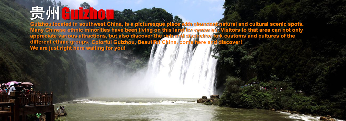
Guizhou is home to many national 5A-level tourist attractions and UNESCO World Heritage Sites, including Huangguoshu Waterfall, Fanjing Mountain, Loong Palace, and Qingyan Ancient Town.
 Ask Questions ?