
Skype: neodalle-travel
Tel: +86 135 7447 2266
E-mail: sales@visitaroundchina.com
Mount Changbai, which is in fact a mountain range, is stunningly beautiful, especially in winter, but its summer weather appeals to many since it is never hot here, and even summer evenings are refreshing if not outright chilly. The best part of Mount Changbai is its unspoiled nature, thanks, surely, to the fact that the mountain range was considered sacred, and thanks especially, perhaps, to the fact that at the time when this mountain range might otherwise have seen its pristine forests depleted, the Jürchens cum Manchus who had an even greater cultural-religious attachment to the mountain than did the Han Chinese, and who were China's rulers at the time (i.e., the period of the Qing Dynasty), issued special decrees that protected the mountain range from such ecological abuse.
As a mountain range, Changbai, which covers an area of over 8000 square kilometers, is characterized by ridges and gorges, and of course, by its virgin forests. Changbai has several peaks, 16 of which exceed 2500 meters above sea level, with its highest peak, Baitou Peak, at an elevation of 2691 meters. Mountain ranges are naturally synonymous with water, and Changbai is no exception. Besides its crater lake, Lake Tianchi, Changbai gives birth to three major rivers - the Songhua, Tumen and Yalu - as well as to a number of minor rivers, countless rivulets, and a number of lesser lakes. Where there are mountain rivers, there is always the likelihood of a waterfall, and here too, Mount Changbai does not disappoint: its Changbai Waterfall (described in greater detail below), though not the tallest waterfall in the world (i.e., in terms of the longest drop), is nonetheless the tallest waterfall among the waterfalls of volcanic mountains.
Changbai is also home to lesser waterfalls (10 of them, to be exact), and to a large number of thermal springs, many of which have an ideal temperature for bathing - and some of whose waters also have an ideal mineral content relevant to balneotherapy - making the area a popular spa for those who prize the therapeutic properties of natural thermal springs. The locals, though, amuse themselves by boiling eggs in the hottest of the hot springs, some of which, due to their mineral content, can impart a color to the boiled eggs - anyone for Changbai Easter Eggs?
Due to its great height, the mountain range offers four different biotopes that correspond to four different climate zones, from a temperate zone at its base to a frigid zone at its peak. The animals and plants that exist in any given biotope are in large part determined by the climatic conditions of the climate zone in question, though the biotopes are not mutually exclusive - some local overlapping occurs, as some plants and animals tolerate a greater climatic range than others. Mount Changbai National Nature Reserve's wildlife include 43 threatened species (i.e., under state protection), such as the sika, the sable, the lynx, the black bear, the otter, the goral (a type of antelope (Nemorhedus goral) resembling the chamois), the leopard and the Siberian tiger. State protection has also been extended to the Reserve's golden eagle. In all, there are some 1200 animal species that make Changbai Mountain Range their home.
The Reserve's varied plant life include 2277 currently known species (the list is expanding, for scientists from home and abroad continually comb the mountain range in search of new species), the large majority of which belong to the higher plants (an example of lower plant species are fungi). Some of the major tree species are white birch, elm, mangrove, spruce, and the Reserve's own pine species, the Changbai Pine. There are also hazelnut trees and other nut trees in the Reserve, as well as a plethora of medicinal plants, including herbal roots such as ginseng and dangshen (aka the Asiabell Root), and of course there are countless mushrooms here, some of which are edible, though only neophytes interested in identifying them should pluck them, and only those who have expert knowledge of the mushrooms should undertake to eat them, as many varieties are poisonous, including some that are deadly. Some of the Reserve's plant species are under state protection.
Deserving of special mention among Mount Changbai's profuse flora is the Changbai Pine, aka Meiren ("Beauty") Pine, considered a geographical mutation of the Scots Pine (Pinus sylvestris). The Changbai Pine is native to the Edaobai River area of Changbai Mountain. It is a typical coniferous evergreen tree, albeit, of medium stature. The tree's average height is about 30 meters; its average diameter, 40 centimeters, making it a somewhat slender tree. The crown of the tree is umbrella-shaped. Its bark is a scaly grey-brown on the lower trunk, the "scales" of irregular, retangular shape, while the bark farther up the trunk is thinner, often flaky, its "scales" brownish to reddish yellow, and with curved rather than straight lines.
The tree's overall gracious shape has earned it the nickname Beauty Pine. Despite its gracious form, it is a very hardy tree type, rarely plagued by pests and the like, and grows to a ripe old age of 400 years or so. It can also tolerate weather extremes, and, due to its elasticity, it can also tolerate heavy snow storms (it simply bends slightly, dumping the accumulated snow from its "umbrella"). The Changbai Pine, whose species name in Latin is Pinus sylvestris variant sylvestriformis, exists only on soils rich in volcanic ash, such as on Mount Changbai.
Though Mount Changbai exudes calm today, the large currently dormant volcano at the base of Lake Tianchi remains a potentially active volcano - geologists classify it as a 'moderately active strato-volcano', and they continue to monitor it, also with the help of space-borne technology (among others, the European Space Agency, ESA, is involved in tracking the volcano). It latest eruption was in 1702, while previous recent eruptions were recorded in 1668 and 1597, all three eruptions occuring within a relatively short time span, in terms of the geological clock. Despite this, you face greater a greater statistical likelihood of being run over in traffic than being on Mount Shangbai the next time it erupts!
What to see?
The landscapes on Mount Changbai are of the picture-postcard variety, with over 30 scenic sites, 9 of which are profiled below, and which offer unique geographical characteristics of interest to nature lovers. The view from any of Mount Changbai's 16 tallest peaks is intoxicating, while the view from Tianbao Peak especially makes you feel that you are standing on the roof of the world.
Mount Changbai National Nature Reserve was established in 1960, spanning an area of some 200,000 hectares, and with Lake Tianchi at its center, and thus with a huge polymorphous volcano at its core. The Reserve is one of the earliest and most important nature reserves in China. The Reserve is characterized by incredible landscapes and distinct biotopes characteristic of northern Eurasia that cover the mountain range from its base to its peaks. Red deer abound here, alongside the many threatened species. Migratory birds include the common mallard, the Mandarin duck and the black stork. The Reserve includes 50 higher animal species, 50 fish species, and 280 bird species - and counting! There are over 1000 insect species in the Reserve.
Both the government of the PRC and the government of the DPRK (North Korea), under the counsel of UNESCO's World Heritage Foundation, have agreed to work together to preserve the pristine beauty of Mount Changbai, with an eye to eventually have the mountain range officially listed as a World Natural Heritage Site, jointly administered by the two countries. Also South Korea is interested in this initiative, as it too regards the mountain as sacred (the current split between North and South Korea is of course artificial and will someday hopefully end). Some tensions have occured over the "proprietary rights" to the mountain between China on the one hand, and the two Koreas on the other, though this will hopefully be resolved amicably, for the sake of the preservation of the mountain and its exceptional biosphere - now recognized by the UN as being important to the biodiversity of the planet.
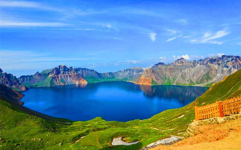
Lake Tianchi ("Heavenly Lake"), aka Tianchi of Baitou Mountain, is an oval-shaped crater lake lying in the "funnel" - sometimes called a cone - of a dormant volcano. The cone is itself generally formed over a long period of time, via successive eruptions, during which the volcano spews out lava, building up the sides of the cone, much like the cone of an ant hill is formed. The moutain's 16 highest peaks - 7 lying within the DPRK and 9 lying within China - all surround the crater, and were in fact formed by the lava which the volcano spewed out. Over time, water accumulated in the crater, also fed by underwater springs, forming a lake. Given its pristine beauty, especially in late autumn through winter, Lake Tianchi is understandably the most frequented scenic site on the mountain.
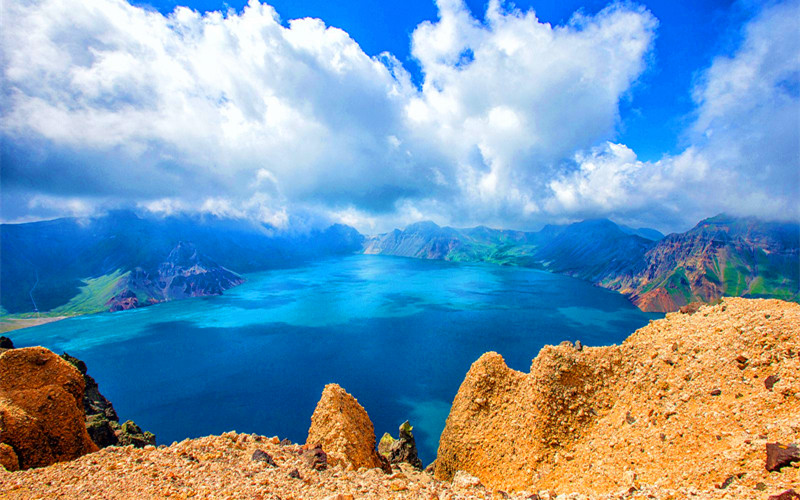
At 2192 meters above sea level, Lake Tianchi represents an enormous natural reservoir, with a surface area of some 10 square kilometers. On a calm day in clear weather, the lake has been likened to a priceless jade surrounded by 16 sharp spikes, guarding it. Some say that the best season in which to view the lake is during the cold months, while others claim that the cloudless skies of midsummer offer the clearest view of the lake and its surrounding peaks. Both views of Lake Tianchi surely have their respective justifications, though, regardless of the season, a trip to Lake Tianchi is a memorable event. On its northern edge, the lake spills over the crater's lip, forming the Chengcha River, on which is located, farther down the side of the mountain, the next scenic site in this listing, Changbai Waterfall.
On its northern rim, between Tianhuo Peak and Longmen Peak, Lake Tianchi spills over, forming the Chengcha River. 1250 meters farther below, the Chengcha River glides over a cliff, forming Changbai Waterfall. 68 meters below this, the river continues its journey down the mountain. By late fall, much of the force of the waterfall has dissipated, as has the Chengcha River itself, since this is a run-off river.
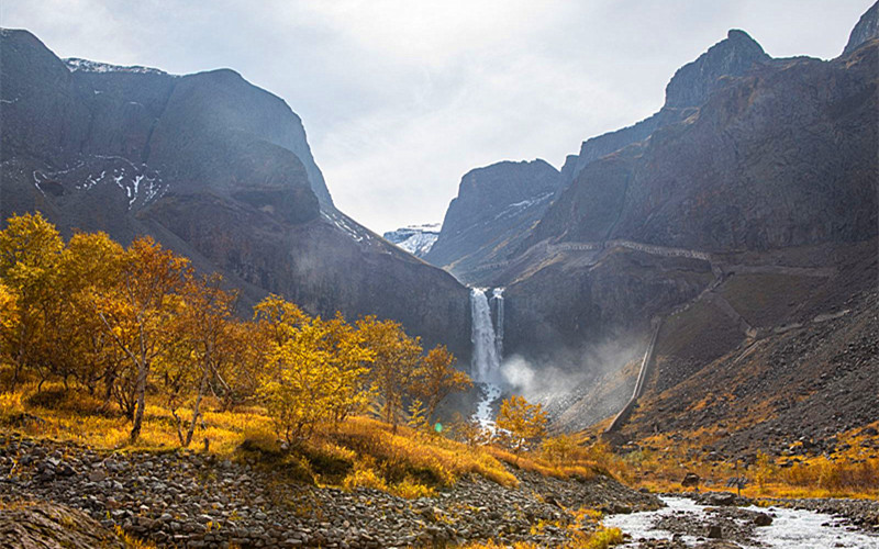
In the dead of winter, the river and its waterfall, reduced to a trickle, eventually freeze solid. In the center of the lip where the Chengcha River spills over the cliff, forming Changbai Waterfall, is a large stone, dubbed "Niulangdu", that splits the waterfall into two halves. Behind the curtain of falling water is a cave-like depression in the mountain, which allows visitors a chance to go behind the waterfall and look out through it onto the slopes below. When the river is running at peak force, one cannot avoid being doused by the fine, vapor-like spray from the waterfall on making this behind-the-curtain journey. On this side of the mountain, the roar of the waterfall at peak force can be heard in the valley below, and because this is essentially run-off water from the melting winter ice pack on Mount Changbai, it is so cold that one can actually feel the chill in the air as one approaches the waterfall.
Heifengkou ("Black Wind Pass") is a narrow pass on the northern slope of Mount Changbai, not far from Changbai Waterfall. Gale-force winds blow through it incessantly, occasionally reaching gale force 5 (on a normal Beaufort Scale of 1-12, though the scale extends to 17 when applied to typhoons), when small black lava stones can even be transported by the wind. However, one can get a panoramic view of Changbai Waterfall from the summit of Black Wind Pass.
Spread out across the vast expanse below Black Wind Pass are countless thermal springs, some of which reach a temperature of 80 degrees Celsius (100 degrees Celsius is boiling), hot enough to boil eggs, and since many of these hot springs contain minerals that have dyed the surrounding stones with bright colors such as blue, red, green and yellow, the local people - to the amusement of tourists, especially children - boil eggs in these springs, resulting in "Easter Eggs" in a variety of bright, natural colors.
Many of these thermal springs have a perfect temperature for bathing, which many tourists indulge themselves in for the pure joy of it, while some of the thermal springs also possess a mineral content (not the discoloring kind!) that is said to be therapeutic. The most famous such hot spring spas are Changbai Hot Springs, Tiyun Hot Springs and Hubin Hot Springs. Lesser known spas include Reed Hot Springs, Celestial Bridge Hot Springs, Shibadaogou Hot Springs, Yujiang Hot Springs and Yaoshui Hot Spring. A steaming hot bath in one of these thermal springs on a winter's day, surrounded by ice and snow, is said to be a tonic experience. There are also 13 thermal geysers here.
Located some 30 kilometers east of Tianhuo Peak, Fairy Bathtub Pool is a small pool, almost perfectly round and with a surface that is mirror-like, so calm is the pool, except for one spot, where a small geyser shoots forth. According to a Jürchen/ Manchu legend, this is the place where three fairies fell from heaven and bathed. The youngest of the three swallowed a fruit, became pregnant, and gave birth to a handsome boy nicknamed Bukuli, but whose family name was Yongshun and who could speak already as he emerged from the womb. Bukuli, according to the legend, sired a line of Yongshuns down to the Yongshuns who became the emperors of the Qing Dynasty.
In hommage to this legend, a county magistrate by the name of Liu Jianfeng, during the final year of the reign (CE 1875-1908) of Emperor Guangxu, came to this enchanted - and enchanting - pool and set up a stone monument for worship, on which were engraved the words "Fairy Bathtub Pool", and that is how this theretofore unnamed pool got its name.
Fairy Bathtub Pool is a small volcanic lake, where the water is clear and shallow, and where water plants grow bountifully. Despite the extreme elevation, no ice forms in the center of the pool in winter, and no duckweed grows here in summer, nor is there any obvious inflow or outflow to and from the pool, yet its waters remain fresh, with an abundance of fish, birds, and plants (it is obviously spring-fed - and drained - though no one knows quite how). Cranes wade its shallow edges. Pine trees have been planted around the pool, and wild flowers in abundance spring up in the meadow surrounding the pool during the summer months, giving the pool a fairlyland appearance.
Over 100 volcanoes are scattered about Mount Changbai. The altitude of the largest volcano is about 2600 meters above sea level; its diameter, roughly 4.5 kilometers; its depth, about 800 meters. The view of the crater from its rim - and note that these crater walls are raised in relation to the surrounding terrrain, having been deposited there by successive eruptions - is very impressive. The altitude of the smaller volcanoes on Mount Changbai is around 1000 meters or so. The shape of these craters is in the form of a somewhat sunken (no longer raised, i.e., time-worn), somewhat crescent-shaped funnel. Some of the more well-known smaller volcanoes are Dong'emao Peak, Xi'emao Peak, Xima'an Mountain, Dongma'an Mountain, Red Peak and Old House Hill.
Mount Changbai Grand Canyon, aka Jinjiang Grand Canyon, is believed to originally have been formed as a cleavage brought about by an earthquake that occurred in conjuction with a particularly violent volcanic eruption of the present-day 'moderately active strato-volcano' that lies beneath Lake Tianchi. The subsequent massive overflows from Lake Tianchi in the wake of various ice ages, plus the erosive effects of rain and wind over time, have only eroded the cleavage more, leaving the gorge, or grand canyon, that one sees today.
The large, odd-shaped lava stones that dot the canyon floor (the imaginative Chinese have naturally given these stones names based on the respective images that they project, such as elephants, camels, seals, peacocks, etc.) are remnants from previous eruptions, spewed out of the volcano. Mount Changbai Grand Canyon is 70 kilometers long, varies in width between 200-300 meters, and varies in depth between 100-200 meters. While the large stones remain, any loose mud, silt, gravel and smaller debris has been washed away over time, deeping the gorge. The proud Chinese quite naturally feel that their Grand Canyon is at least on par with the much-touted American Grand Canyon.
Little Lake Tianchi is situated about 3 kilometers north of Changbai Waterfall. Little Lake Tianchi consists in fact of two bodies of water: one is what one would typically call a lake, with crystal blue waters, while the other is very shallow with a yellowish bottom, and is oftentimes partially or completely dried up, revealing its ocherous bottom more clearly. The yellowish "lake" is situated only about 200 meters from the blue lake, which, in the right lighting - and from a vantage point above - reflects a silvery surface, prompting the local populace to liken the two bodies of water to silver and gold cups. Some see them as a married couple, which has given rise to the lake's nickname "Couple Lake".
How to get there?
All of the smaller cities around Changbai Mountain have airports that accommodate smaller airplanes, and with bus connections on to the mountain. For example, the cities of Changchun, Tonghua, Jilin, and Yanji all have airports. Since Yanji lies closest to the entrance to the mountain (the bus ride from Yanji to Changbai Mountain takes about 4 hours), it is naturally the best choice.
 Ask Questions ?


