
Skype: neodalle-travel
Tel: +86 135 7447 2266
E-mail: sales@visitaroundchina.com
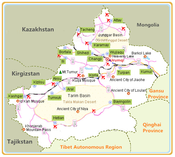 Changji Hui Autonomous Prefecture is located at the northern foot of the Tianshan Mountains, on the southern fringes of the Jungar Basin and bounded on the northeast by the People's Republic of Mongolia. Changji Hui Autonomous Prefecture covers a total area of 94 thousands square kilometers, with a population of over 140 ten thousands.Changji Prefecture is bounded on the east by Urumqi and Hami in neighborhood of Turpan in the south, while Mongolia lies to the northeast of the prefecture.
Facts of Changji Prefecture
Full Name: Changji Hui Autonomous Prefecture
Chinese Name: 昌吉回族自治州 (chāng jí huí zú zì zhì zhōu)
Population : 1,700,000
Area: 73,660 square kilometers (28,440 square miles)
Nationalities: Hui, Han
Administrative Division: four counties (Hutubi, Manas, Qitai, Jimsar); one autonomous county (Mori Kazak Autonomous County); two county-level cities (Changji, Fukang)
Seat of the Prefecture Government: No.10, North Yan'an Road,Changji City.
History of Changji
China's central government of the day extended its sphere of influence to Changji with the establishment of the Protectorate of the West Region (Xiyu Duhufu) in 60BC during the Western Han Dynasty (206BC-24AD). In 1884, a province was set up to administrate Xinjiang, and this area belonged to Dihua Fu.
What to see in Changji ?
The prefecture of Changji lies at the foot of the Tianshan Mountains on the southeastern edge of the immense desert in the Junggar Basin. The terrain in which Changji is situated inclines to the south and is part of the hinterland of Asia. Bogda Peak is the highest peak in the eastern part of the Tianshan Mountain range. Situated in the south of Fukang County it has an altitude of 5,445 meters. The distances as the crow flies, from the peak to Urumqi and the Fukang county seat, are 60 and 49 kilometers respectively. It is one of the fifteen peaks of Xinjiang open to tourists.
 |
 |
 |
| Heavenly Lake | Xinjiang Multicolored Bay | Mount Tianshan |
When to visit Changji ?
Basking in a continental climate, the prefecture has characteristically dry weather with great temperature variations between day and night. To the south, there are the obvious climatic features of the mountains, while to the north there is the typical climate of a dry desert. The average annual temperature is 6.8℃. The transitional spring and autumn seasons between summer and winter, are short. Summer and autumn are the best seasons to visit the Prefecture. By avoiding the burning sun at noon, the summer here can be refreshing.
How to get to Changji ?
Changji is 38 kilometers from downtown Urumqi and 18 kilometers from Urumqi International Airport. Changji Railway Station is located 10 kilometers south of its city proper. In addition, the prefecture's central bus station is located in Wuyi Lu.
 Ask Questions ?


