
Skype: neodalle-travel
Tel: +86 135 7447 2266
E-mail: sales@visitaroundchina.com
 Qinghai Province is located in the northeast of Qinghai-Tibet Plateau. It is 1,200 kilometers from east to west in length and 800 kilometers from west to north in width. It is in the northwest inland District. It borders with Gansu Province, Tibet, Sichuan and Xinjiang, with a total area of 720,000 square kilometers. The area of Qinghai Province occupies one thirteenth of the total area of China.
History of Qinghai
Qinghai has a long history, and is located in the cradle of the Chinese nation - the source of the Yellow River, the Yangtze River. As early as the late Paleolithic age, dating back 20,000 or 30,000 years ago, Qinghai's ancestors had lived in today's Qaidam Basin and Kunlun Mountains area. According to archaeological excavations, many ancient cultural relics prove that the development of Qinghai has at least five or six thousand years of history. It has brilliant Neolithic culture and its Qinghai painted pottery is world famous.
 Geography of Qinghai
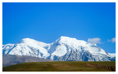
The fundamental characteristic of the topographic features of Qinghai Province is its high relief. The west part is high and the east part is low, the south and north parts are high while the middle part is low, which is another outstanding characteristic of the terrain of Qinghai Province. Most of the province is erected and mountain ranges stand side by side. The region that is over 3,000 meters above sea level occupies 85% of the total area of Qinghai Province; the highest top lies in the highest peak of Mt. Kunlun-Qingxin (6,860 meters above sea level) Peak, which is in the intersection of Qingxin in the west of the Province; the lowest place is in the valley of Xiachuankou in Minhe, 1,650 meters above sea level. Mt. Qilianshan in the north, Mt. Kunlun in the middle and Mt. Tanggula form the basic skeleton of the terrain of Qinghai Province.
The ground falls from the west to the east, from the south to the north gradually, slopes from the south and the north towards the middle. Qilianshan Mountain is in the north of Qinghai Province, flat and vast Qingnan Plateau is in the south, Caidamu Basin, Qinghai Lake, and Chakagonghe Basin are in the west and the Hehuang Valley hills area in the east. Qinghai is in the border of Qinghai-Tibetan Plateau and the west of Loess Plateau, in the transitional zone of these two plateaus. There are plateaus, hills, basins, mountains and valleys. The five geographic types distribute crisscrossed. There are a chain of undulating hills, rolling mountains, crisscrossed rivers and a chain of basins here.
 The southern part of Qinghai Province is the headstream of the Yellow River and the Yangtze River, commonly called stream source area. Not only the main streams of the Yellow River and the Yangtze River rise in Qinghai, but also the big tributaries of the upper reaches of the Yangtze River (the Yanglong River, the Dadu River) and the Yellow River (the Yao River, the Daxia River) and some inland rivers (the Caidamu River and the Geermu River) all rise the southern part of Qinghai Province. The Lanchangjiang River in the upper reaches of the Meigonghe River, which is the largest international river in Southeast Asia, also takes rise in Qinghai Province. The southern part of Qinghai Province is a stream source area in deed as well as in name. It is also called Qingnan Plateau here. It is in the hinterland of Qinghai-Tibet Plateau, 4,000 meters above sea level, peaks covered snows all year around. Rich ice and snow resources have become the primary headwaters of various rivers. The main stream of the Yangtze River is 1,200 kilometers in Qinghai Province, with drainage area 150,000 square kilometers; the main stream of the Yellow River is 1,964 kilometers in Qinghai Province, with drainage area 150,000 square kilometers.
Qinghai People
There are 43 ethnic groups in Qinghai Province, they live here harmoniously. The population of minorities occupies 42.8% of the total population of the Province. The minorities that have lived here since ancient times are Tibetan, Hui, Tu, Shala, Mongolia, etc.
Indigenous minorities in Qinghai are Tibetan, Hui, Monguor, Salar and Mongolian, and Monguor and Salar ethnic group is unique in Qinghai. Five indigenous ethnic concentrated areas are regional autonomies, successively set up 6 autonomous prefectures and 7 autonomous counties. Among them, there are five Tibetan autonomous prefectures (Yushu, Guoluo, Hainan, Haibei, Huangnan Tibetan autonomous prefecture), a Mongolian Tibetan autonomous prefecture (Xunhuan Salar Mongolian Tibetan autonomous prefecture), a Hui minority autonomous counties (Hualong, Menyuan Hui minority autonomous county), 2 Hui and Monguor autonomous counties (Minhe and Datong the Hui minority autonomous counties), a Mongolian autonomous county (Henan Mongolian autonomous county). Autonomous areas area of 98% of the total area of 72 square kilometers, the autonomous areas of minority population accounts for 81.55% of the province's minority population. In addition, there are 28 nationality townships in the province.
Qinghai Tourism
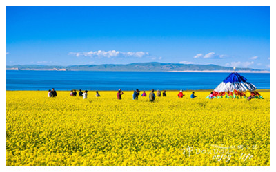
Qinghai Province possesses rich tourist resources. There is one national scenic spot, one national famous historic cultural city, 6 national key relic monuments, 5 national natural reserves, 3 national forest park, and 300 provincial scenic spots. There are some monopolistic tourist resources in China: bird island on Qinhai Lake which is called bird kingdom, Mengda natural reserve which is called "Xishuang Banna in Plateau", the famous Tibetan Buddhism temple-Taer Temple, the mysterious culture of Kunlun, a lofty salt bridge in 1000-li Gobi and the expedition in glacier and snow mountains. At present, there are over 40 exploitative scenic spots and 19 tourist routes...More
 Ask Questions ?


