- Home
- Province Guide > Tibet >
Tibet Maps
Tibet is an inalienable part of Chinese territory. Since the Yuan Dynasty, the government had jurisdiction over Tibet. The Chinese government had direct control over Tibet since 1965. Nowadays, the economy of Tibet and the living standard of Tibetan are promoted largely with the help of the Chinese government.
Tibet Tourism Map
Tibet Autonomous Region, located in the southwest of China with a land area of 1.22 million square kilometers, is the second-largest province in China. As one of the 5 Ethnic Minority Autonomous Region in China, Tibet borders the Xinjiang
Uygur Autonomous Region and Qinghai Province to the north, Sichuan and Yunnan to the east, India, Nepal, Sikkim, and Burma to the south, and this borderline is about 4,000 kilometers. Lying on the Qinghai-Tibet Plateau with an average altitude of 4,000 meters, Tibet is the highest region in the world and called “the roof of the world”.
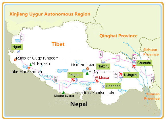
Tibet is the second largest region in China with a great number of attractions, so the travel map of Tibet is essential for tourists to know about where the most famous scenic spots are. And due to the unique features of Tibetan geography, culture, customs, and history, tourists can enjoy different kinds of Buddhist monasteries in different prefectures, explore holy lakes and sacred mountains with ancient legends, just Mount Everest, Lake Namtso, Tashi Lhunpo Monastery, Mount Kailash, etc.

 Ask Questions ?


