
Skype: neodalle-travel
Tel: +86 135 7447 2266
E-mail: sales@visitaroundchina.com
Facts of Karamay
English Name: Karamay
Chinese Name: 克拉玛依市 (kè lā mǎ yī shì)
Population: 330,000
Area: 9,500 square kilometers (3,668 square miles)Area: 9,500 square kilometers (3,668 square miles)
Nationalities: Han, Uygur
Administrative Division: 4 districts (Karamay, Dushanzi, Baijiantan, Urho)
History of Karamay
Karamay is Uygur word meaning 'black oil'. It gained this name for the Black Oil Mountain near the city proper. After the first oil well of the mountain began to work in 1955, the city entered a great era of exploitation and construction.
What to see in Karamay?
The terrain is long and narrow, higher in the northwest and lower in the southeast. Generally speaking, its western and northern territories are occupied by mountains, while its central and eastern parts are vast open flat spaces.
 |
 |
 |
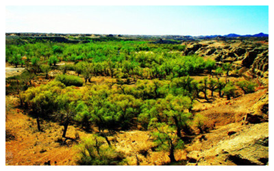
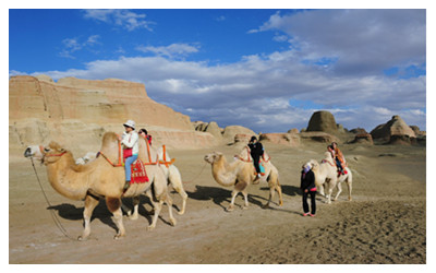
| Baiyanghe Gorge | Ghost City in the World | Nine-Gragon Pood |
When to visit Karamay?
The region has a typical continental climate characterized by a lack of rain and quite windy spring and autumn. Winter is extremely cold and summer is roasting, generating a large temperature difference between these two seasons. Comparatively, its spring and autumn are short during a year.
How to get to Karamay?
Karamay Airport is 17 kilometers (11 miles) from the city's downtown area. At present, only one daily flight leaves for Urumqi in the morning for an hour's journey. If going to Urumqi from the bus station of Karamay, a ten hours' drive may be needed.
Karamay Travel Tips
Special Local Pproducts: embellished cap, woolen carpet
Useful Telephone Numbers:
Tourist Complaints: 0990-6888861, 6623009
Weather Forecast: 121
Zip Code Inquiry: 184
 Ask Questions ?


