
Skype: neodalle-travel
Tel: +86 135 7447 2266
E-mail: sales@visitaroundchina.com
 |
 |
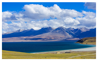 |
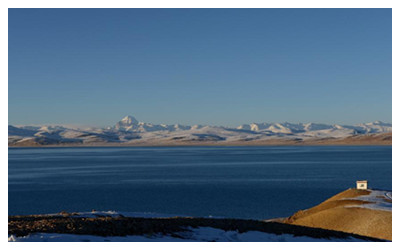
| Ruins of Guge Kingdom | Pangong Tso Lake | Manasarovar Lake |
 |
 |
 |
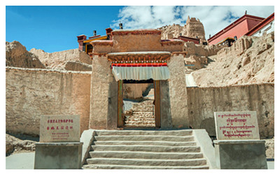
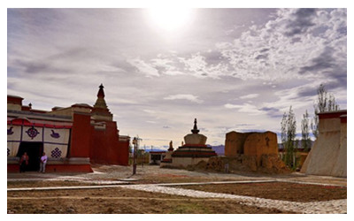
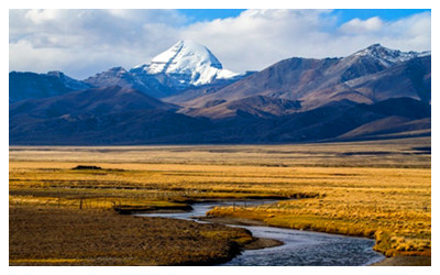
| Tholing Monastery | Kailash Mountain | Rakshastal Lake |
From the 10th century to the early 17th century, prosperous and powerful Guge Kingdom ruled here and promoted Buddhism, leaving many exquisite religious art works including wall paintings, sculptures and stone carvings. It built the first Buddhist temple in Ngari - Tholing Monastery. More than 300 caves and houses relics built in the mountains can be seen in the Ruins of Guge Kingdom. Besides, there are many mountain ranges in the territory, including the Himalayas and the Gangdese Mountains. The Mount Kailash is lionized by many religious denominations. The beautiful Lake Manasarova, Pangong Tso Lake and Lake Rakshastal also deserve a visit.
When to visit Ngari?
Basically, the area enjoys a plateau monsoon climate. In summer, the monsoon from the Indian Ocean may bring precipitation to this area. During winter and spring, gales and strong temperature drop may frequently occur. Its annual average temperature remains around 19ºC. During daytime in August, the temperature is above 10ºC, but it may drop to the subzero. May to July and September to October are suitable for a visit. Due to the great temperature difference in a day, warm clothes should be the prime priority. The annual rainfall here is extremely slim and mainly happens during July to early September. Road conditions are really awful at that time.
How to get to Ngari?
By Air: Ngari Gunsa Airport is located in the southwest of Shiquanhe Town, Ngari Region. With an altitude of 4,274 meters, this airport mainly operates an airway from Chengdu to Ngari via Lhasa at present. The 1,098-kilometers' journey from Lhasa could be finished in 1.5 hours, which takes at least two days by road. At 05:50 of every Tuesday and Friday, there is a plane of Air China taking off from Chengdu Shuangliu Airport to this airport via Lhasa Gonggar Airport. It will take 4.5 hours for the flight to finish the 2,300-kilometers' journey. Limited by the high altitude of Tibet, every flight could only take 60 passengers at most but 30 people during hot summer. The flight ticket of the day should be purchased at the local designated ticket office. No online ticket-booking service is opened at present.
Ngari Travel Tips
Local Highlights: Where there are religious, there are pilgrimages. Kangrinboqe is considered as a sacred mountain in Hinduism, Buddhism, Jainism and Bon religious. Every year, devotees from Tibetan, India, Nepal and Bhutan will make pilgrimages to the sacred places for blessing following the old traditional way: saluting full body kowtow all the way from afar and moving around and around the sacred mountain.
Local Products: highland barley wine.
 Ask Questions ?


